


Generated by AI

Saving the Caspian Sea and Redistributing Eurasia’s Water: Is Diverting Northern Rivers Possible?
The Caspian Sea has entered a period of accelerated shallowing, the consequences of which are already affecting ports, oil terminals, fisheries, and coastal ecosystems. If the current trend continues, the problem will no longer be exclusively environmental: changes to the coastline will affect transport corridors, the energy sector, human settlements, and the economic interests of all five Caspian littoral states.
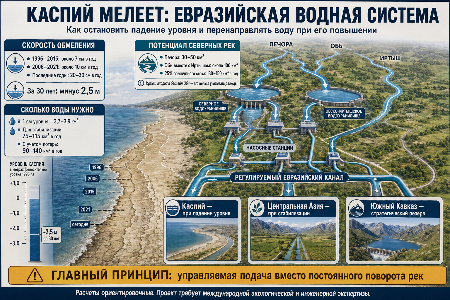
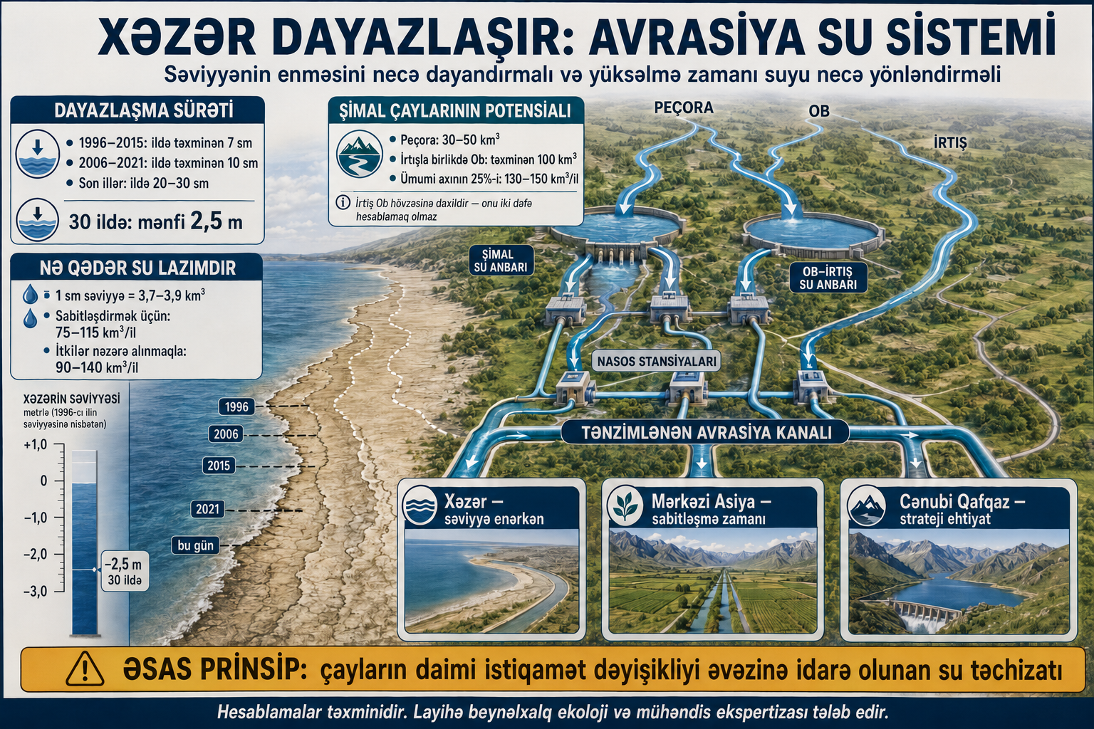
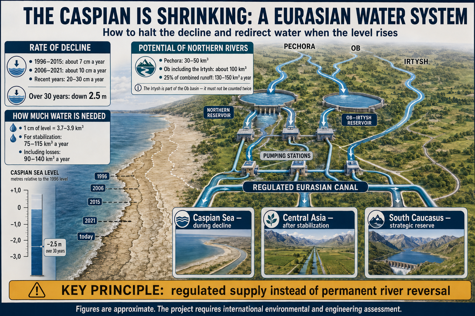
One of the most radical options for saving the sea could be the partial diversion of water from Russia’s northern rivers, primarily the Pechora and the Ob basin, which includes the Irtysh. Preliminary calculations show that one quarter of their combined runoff is theoretically comparable to the Caspian Sea’s current water deficit.
However, this cannot be reduced to simply “reversing the rivers” and constructing a permanently operating canal. Historically, the level of the Caspian Sea has changed cyclically. Following a prolonged decline, it may begin to rise again, creating the risk of flooding vast coastal territories. A more forward-looking concept could therefore involve a regulated Eurasian water system capable of directing water to the Caspian Sea, Central Asia, or the South Caucasus, depending on prevailing conditions.
The Caspian Sea Is Shrinking at an Increasing Rate
The current period of falling water levels began after 1995. According to a study published in the scientific journal Communications Earth & Environment, the Caspian Sea lost an average of about seven centimetres of water level annually between 1996 and 2015. Between 2006 and 2021, the rate of decline approached ten centimetres per year. During this period, the sea lost approximately 15,000 square kilometres of surface area, primarily in its shallow north-eastern section.
The process has accelerated in recent years. According to Azerbaijani Deputy Minister of Ecology and Natural Resources Rauf Hajiyev, the sea level has fallen by 93 centimetres over the past five years, by 1.5 metres over the past decade, and by approximately 2.5 metres over the past 30 years. The current rate of decline is estimated at 20–30 centimetres per year.
The sea level has approached an elevation of 29 metres below the global mean sea level. The changes are most visible in the Northern Caspian, where the average depth is only a few metres. Even a one-metre fall in the water level can cause the coastline there to retreat by several kilometres.
Shallowing is already complicating navigation and port operations, forcing authorities and companies to undertake costly dredging and reduce vessel loads. Sturgeon spawning grounds are shrinking, wetlands are degrading, and Caspian seal breeding areas are under threat. At the same time, the exposed seabed may become a source of salt and dust erosion, as happened around the Aral Sea.
Why the Sea Is Losing Water
The Caspian is an enclosed body of water with no natural outlet to the World Ocean. Its level depends on the balance between river inflow, precipitation, evaporation, water flowing into the Kara-Bogaz-Gol Gulf, and human consumption.
Approximately 80 percent of the river water entering the Caspian comes through the Volga. However, part of the Volga’s runoff is retained by reservoirs and used by industry, agriculture, and cities. During low-water years, the volume reaching the sea falls sharply.
At the same time, climate change is increasing air and sea surface temperatures, intensifying evaporation. Any possible increase in precipitation is unlikely to compensate for the growing loss of water.
The current decline therefore cannot be attributed exclusively to dams on the Volga or solely to global warming. The crisis results from several interconnected factors: climate change, reduced river inflow, river regulation, human water withdrawals, and increasing evaporation.
Projections: A Decline of Eight to Fourteen Metres by the End of the Century
It is impossible to predict the precise level of the Caspian Sea in 2100. The outcome will depend on the pace of global warming, precipitation levels, conditions in the Volga basin, and the scale of water consumption.
A study based on 15 climate models presents two principal scenarios:
- Under a moderate warming scenario, the Caspian Sea could fall by approximately eight metres, although individual models produce a range of two to 15 metres.
- Under a high greenhouse gas emissions scenario, the decline could reach approximately 14 metres, with estimates ranging from 11 to 21 metres.
Some calculations suggest a decline of 20–30 metres, although such estimates may be exaggerated because the shrinking surface area of the sea would also reduce the area from which evaporation occurs.
Even a five-metre decline would radically alter the regional map. A significant part of the Northern Caspian would disappear, while Russian and Kazakh ports would find themselves far from the present coastline. Baku, Alat, Turkmenbashi, and other ports would face a permanent need to deepen their approach channels.
If the water level falls by nine metres, the Caspian Sea could lose about 23 percent of its surface area. An 18-metre decline could reduce its area by roughly one third. The sea would not disappear completely because of its deep central and southern basins, but its coastline, ecosystem, and economic role would change beyond recognition.
How Much Water Does the Caspian Sea Need?
The surface area of the Caspian Sea is estimated at approximately 370,000–390,000 square kilometres. A one-centimetre change in its water level therefore corresponds to approximately 3.7–3.9 cubic kilometres of water.
The approximate relationship is as follows:
| Change in water level | Corresponding volume of water |
| One centimetre | 3.7–3.9 cubic kilometres |
| Ten centimetres | 37–39 cubic kilometres |
| Twenty centimetres | 74–78 cubic kilometres |
| Thirty centimetres | 111–117 cubic kilometres |
If the sea is losing 20–30 centimetres annually, stopping the decline would require compensation for a net deficit of approximately 75–115 cubic kilometres of water per year.
The actual withdrawal from the donor rivers would have to be larger because some water would be lost during transportation through evaporation and seepage. Depending on the technology used, the total required volume can be preliminarily estimated at 90–140 cubic kilometres per year. This is an indicative calculation, not a completed engineering assessment.
A one-time replenishment would not solve the problem. If the negative water balance continues, additional inflow would have to be maintained annually.
What Could the Pechora, Ob, and Irtysh Provide?
The Pechora’s annual runoff fluctuates between approximately 120 and 200 cubic kilometres. One quarter of this volume amounts to 30–50 cubic kilometres. Up to 70 percent of the river’s annual runoff occurs during the spring and summer flood season. Study of the Pechora Sea
The average annual runoff of the Ob is approximately 400 cubic kilometres. One quarter of that is about 100 cubic kilometres.
Therefore, 25 percent of the combined runoff of the Pechora and Ob could theoretically provide approximately 130–150 cubic kilometres of water per year. This is comparable to the upper estimate of the Caspian Sea’s requirements.
However, the Irtysh cannot be counted separately from the Ob. It is the Ob’s largest tributary, and its water is already included in the total runoff of the Ob river system. Adding one quarter of the Irtysh runoff to one quarter of the Ob’s total runoff would amount to counting the same water twice.
| River system | Approximate annual runoff | One quarter of runoff |
| Pechora | 120–200 cubic kilometres | 30–50 cubic kilometres |
| Ob, including the Irtysh | Approximately 400 cubic kilometres | Approximately 100 cubic kilometres |
| Total | 520–600 cubic kilometres | 130–150 cubic kilometres |
Mathematically, this volume could halt the Caspian Sea’s current decline. Environmentally, however, withdrawing one quarter of the runoff from two of the largest northern river systems would carry exceptionally high risks.
A Project Larger Than the Soviet River Reversal Scheme
The idea of diverting northern rivers is not new. A Soviet project envisaged transferring part of the Ob and Irtysh waters to Kazakhstan and Central Asia. Its first phase would have transferred approximately 27 cubic kilometres annually, equivalent to about seven percent of the Ob river system’s runoff.
The project was terminated in 1986 because of its high cost, technical complexity, and concerns about environmental consequences. The volume of 100–150 cubic kilometres now being considered for stabilising the Caspian Sea would be several times larger.
Such a project would require a system of canals, pipelines, reservoirs, and pumping stations extending for thousands of kilometres. The water would have to cross the divides separating the drainage basins of the Arctic Ocean, Central Asia, and the Caspian Sea. Enormous amounts of electricity would be needed to pump it across these divides.
In terms of scale, this would not be a canal in the conventional sense. It would amount to creating a new artificial river and one of the largest hydraulic engineering systems in history.
The Environmental Cost
The northern rivers do not carry “surplus” water. Their runoff shapes the salinity, ice regime, biological productivity, and circulation of Arctic seas.
Reducing the Pechora’s runoff would affect its delta and the Pechora Sea. Potential consequences include changes to spawning grounds, wetlands, fish resources, and the salinity of coastal waters.
Withdrawing water from the Ob system could affect:
- The floodplains and wetlands of Western Siberia.
- The Gulf of Ob.
- Navigation and fisheries.
- Indigenous communities.
- The transport of nutrients into the Kara Sea.
The issue also has an international dimension. The Irtysh begins in China, flows through Kazakhstan, and then enters Russia. Its water is already used for irrigation, industry, energy production, and municipal supply. Any change in the river’s regime would require the consent of at least three states.
For this reason, 25 percent of the runoff cannot be declared a safe and permanent allocation in advance. It is only a theoretical upper limit whose acceptability would have to be demonstrated through separate studies of each river basin.
The Opposite Risk: The Caspian Sea Could Rise Again
The main weakness of a permanent canal project lies in the cyclical behaviour of the Caspian Sea. Following a prolonged decline from the 1930s to the 1970s, the sea level rose by approximately 2.5 metres between 1978 and 1995. Coastal land, roads, settlements, and industrial facilities were flooded.
If the natural cycle changes again, an additional 130–150 cubic kilometres of water from northern rivers could turn from a means of saving the sea into a source of danger.
At the Caspian Sea’s present surface area:
- Ten cubic kilometres of water correspond to approximately 2.5–2.7 centimetres of water level.
- Fifty cubic kilometres correspond to 13–14 centimetres.
- One hundred cubic kilometres correspond to 26–27 centimetres.
- One hundred and fifty cubic kilometres correspond to almost 40 centimetres.
If the sea’s natural water balance becomes positive while artificial supplies continue, the additional water alone could theoretically raise the level by more than one metre within three or four years. Combined with increased natural inflow, this could create the threat of widespread flooding.
The system must therefore be reversible and controllable. Its purpose should not be to raise the level unconditionally, but to keep the Caspian Sea within an agreed safe range.
From a Canal to a Water Distribution System
A regulated Eurasian water system would be a more rational concept. It could include several routes and redirect flows depending on the level of the Caspian Sea, the volume of water available in the northern rivers, and the needs of recipient countries.
During an accelerated decline, the main volume would be directed towards the Caspian Sea. Once the level stabilised, supplies would be reduced. During a sustained rise, the Caspian route would be closed, with the water either remaining in its natural basin or being redirected for economic and environmental needs in Central Asia and the South Caucasus.
It is essential that freshwater be distributed before it enters the saline Caspian Sea. Releasing it into the sea and then withdrawing it again would require desalination, making the project economically and energetically irrational.
The management system could be based on several operating modes:
| Condition of the Caspian Sea | Operating mode |
| Rapid decline | Increased compensatory supply |
| Moderate decline | Limited supply |
| Stabilisation | Minimum supply or suspension |
| Sustained rise | Closure of the Caspian route |
| Risk of flooding | Preservation of natural northern runoff or distribution to other consumers |
Specific thresholds would have to be determined on the basis of a joint assessment by all five Caspian littoral states. A decision could not be based on a single high-water or low-water year; average indicators over several years would have to be considered.
Central Asia as an Alternative Destination
Central Asia would be the most logical alternative destination for northern river water. Geographically, part of the Ob-Irtysh basin’s resources would be easier to use because the Irtysh already flows through Kazakhstan.
From Kazakhstan, water could be directed:
- To the country’s central and southern regions.
- To the Syr Darya basin.
- To restore selected water bodies and ecosystems in the Aral Sea region.
- To Uzbekistan.
- Through additional water mains, to Turkmenistan.
This strategic reserve is becoming increasingly important because of climate change. The World Bank warns that Central Asia is becoming more vulnerable to drought, land degradation, and competition for water. Agriculture accounts for approximately 90 percent of freshwater withdrawals in the region. By around the middle of the century, Central Asia may pass the point of maximum glacier-fed runoff, after which water flows into its rivers are expected to decline.
However, northern water should not be used to preserve an inefficient agricultural model. If it is directed through outdated open canals, a substantial share will again be lost through seepage and evaporation.
Access to a new source should therefore be linked to irrigation modernisation, drip irrigation, the lining or enclosure of canals, and a reduction in the cultivation of the most water-intensive crops.
The South Caucasus Route
Delivering northern water to the South Caucasus would be technically possible but more expensive. Two routes could be considered.
The first would be a western Caspian pipeline running through southern Russia and Dagestan to Azerbaijan. Water could be supplied to Azerbaijan’s northern regions, Baku, the Absheron Peninsula, the Samur-Absheron system, and reservoirs in the Kura basin. In the longer term, part of the resource could be transferred to eastern Georgia.
The second option would be a freshwater pipeline across the Caspian Sea from Kazakhstan or Russia to Azerbaijan. This would require complex underwater infrastructure, pumping stations, and protection against corrosion and seismic risks.
Delivering water farther into Georgia and Armenia would require pumping it to considerable elevations. Northern water could therefore become an additional strategic reserve for the South Caucasus but would be unlikely to serve as its primary source.
The problem is expected to worsen as the climate changes. The transboundary Kura and Aras rivers remain the region’s main sources of surface water, but the South Caucasus states have no comprehensive agreement on managing the basin as a whole.
Who Would Control the Water?
The political difficulties may prove more challenging than the hydraulic engineering. The Pechora is located in Russia, while the Ob-Irtysh system connects China, Kazakhstan, and Russia. Several additional Central Asian and South Caucasus countries could become recipients.
Before construction began, an international treaty would have to define:
- The minimum environmental flow of the northern rivers.
- The maximum permissible volume of withdrawals.
- The priority of drinking water supply.
- Water allocation rules.
- Operating rules for dry and wet years.
- Grounds for reducing or suspending supplies to the Caspian Sea.
- The price of water and electricity.
- Compensation for environmental damage.
- Dispute resolution procedures.
Consumers could not be guaranteed a fixed volume because the flow of the northern rivers also varies. Contracts would have to distinguish between baseline and variable volumes and provide for automatic reductions during low-water years.
There is also a risk of economic dependence. Cities, industrial facilities, irrigated land, and power plants would emerge around the new water supply. Over time, their owners and operators would begin to regard deliveries as an unconditional right. The same resource could then be promised simultaneously to the Caspian Sea, Central Asian agriculture, South Caucasus cities, and Arctic ecosystems.
The order of priority should therefore be established in advance:
- Maintaining the minimum environmental flow of the northern rivers.
- Providing drinking water to the population.
- Preventing a critical decline in the Caspian Sea.
- Supporting vulnerable natural ecosystems.
- Agricultural and industrial consumption.
A Possibility That Still Requires Proof
The preliminary water balance calculation confirms that partially diverting the Pechora and Ob-Irtysh systems could theoretically halt the Caspian Sea’s current decline. The 75–115 cubic kilometres needed annually are comparable to one quarter of the combined runoff of these rivers.
A mathematical correspondence, however, is not enough. The environmental acceptability of the withdrawal must be demonstrated, and the actual transportation losses, energy consumption, construction costs, and consequences for the Arctic seas must be calculated. Until then, the idea remains a concept rather than a completed project.
The first step should not be the diversion of one quarter of the rivers’ flow, but a comprehensive programme to manage the Caspian Sea’s water balance. It should include water conservation in the Volga basin, irrigation modernisation, coordinated reservoir management, delta restoration, and adaptation of ports. In parallel, a limited seasonal pilot transfer of perhaps 10–20 cubic kilometres during high-water years could be studied.
More broadly, the shallowing of the Caspian Sea raises the question of future water distribution across Eurasia. Northern regions possess some of the continent’s largest river resources, while Central Asia, the Caspian region, and the South Caucasus are facing a growing water deficit.
The solution may lie not in the mechanical “reversal of rivers,” but in a regulated, multipurpose system capable of supporting the Caspian Sea during periods of decline and supplying arid regions after its level stabilises or begins to rise. Saving one sea, however, must not come at the cost of destroying northern rivers. A workable solution will have to be found between these two risks.


The Caspian Basin
-
The level of the Caspian Sea is falling faster than ports, coastal cities, oil and gas infrastructure and environmental protection systems can adapt. Over the past five years, the sea has lost about one metre; over ten years, approximately 1.5...
-
The Caspian Sea, long regarded as an area relatively insulated from major international conflicts, is rapidly becoming a zone where military, energy and transport interests intersect. Russia retains a dominant position through the numerical strength...
-
At first glance, the Middle Corridor is experiencing a boom. The geopolitical transformation of recent years has turned the Middle Corridor from an alternative route into a critically important artery of Eurasia. The beginning of the war in Ukraine...
-
In recent years, the Caspian Sea has acquired new geoeconomic importance within Eurasia’s transport system. Its transformation into one of the principal transport areas at the intersection of East–West and North–South cargo flows has significantly...


Leave a review