


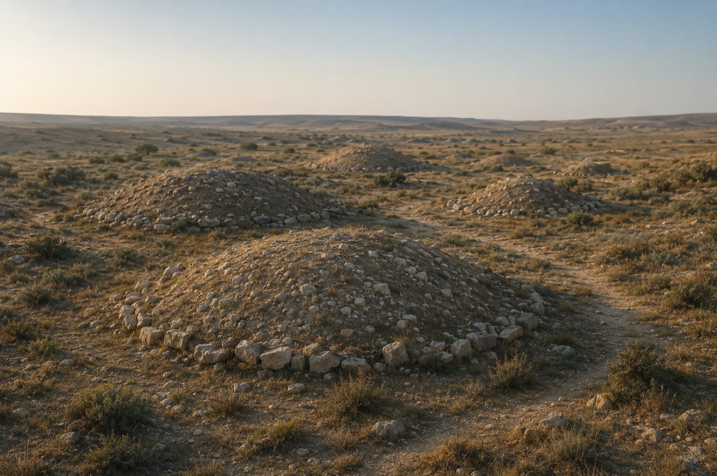
A realistic illustration of the Nardaran burial-mound field: looted mounds, surrounding development and the Caspian Sea on the horizon. AI.

The Vanishing Burial Mounds: How Nardaran’s Ancient Necropolis Became an Anonymous Wasteland
The Bronze Age burial-mound field is officially protected by the state. On the ground, however, the ancient mounds are being damaged, encroached upon by construction and gradually erased from the landscape.
On the northeastern edge of the settlement, where residential houses give way to fenced plots and stretches of dry ground, a number of low, rounded hills have survived. They are barely visible from the road. It would be easy to mistake them for natural irregularities in the terrain or the remnants of old earthworks.
Viewed from above, however, the landscape changes.
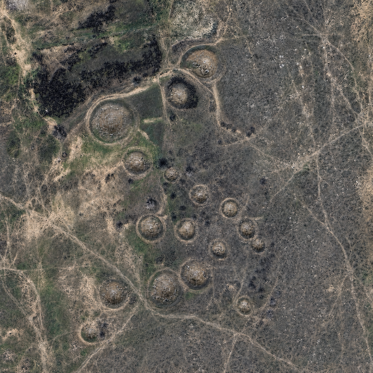
Satellite images reveal circles of varying diameters. Some still retain the outlines of mounds, while others can be detected only through changes in the colour of the soil and vegetation. Several have distinctive depressions at their centres — evidence that someone once broke into them.
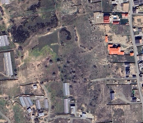
Satellite image of the burial-mound field in Nardaran
These are the remains of an ancient burial-mound field that has been looted, partially destroyed and surrounded by modern development. It dates to the Bronze Age and is officially recognised as a historical and cultural monument of national importance.
In the state register of immovable historical and cultural monuments, approved by Azerbaijani Cabinet of Ministers Resolution No. 132 of August 2, 2001, the site is listed as monument No. 534: “Burial-mound field — Bronze Age — east of the settlement of Nardaran.”
The state recognised its archaeological and historical value at least a quarter of a century ago. But the central question today is no longer whether the monument exists. It is how a state-protected necropolis came to be looted — and why its disappearance continues.
A landscape where history lies in layers
Northern Absheron rarely looks like a place where major archaeological discoveries might be expected. Rocky ground, sand, oil derricks, summer-house developments and rapidly expanding settlements create the image of a territory subordinated to modern needs.
Yet the area between Buzovna, Zagulba, Bilgah and Nardaran contains one of the richest historical landscapes on the Absheron Peninsula. Ancient burials, sacred rocks, petroglyphs, medieval cemeteries, shrines, defensive structures and traces of economic activity from different periods stand close to one another.
The Nardaran burial-mound field forms part of this multilayered history. It demonstrates that long before the modern settlement appeared, the land already possessed a special significance. People did not merely live and graze livestock here. They buried their dead, performed rituals and built funerary structures intended to remain in the landscape for generations.
Azerbaijani archaeologists have noted that Absheron contains monuments from almost every historical period beginning in the third millennium B.C. Settlements, burial mounds, rock carvings, fortresses and religious complexes testify to the peninsula’s continuous occupation.
Yet surprisingly little is known about the Nardaran necropolis itself.
The state register attributes it to the Bronze Age. But published findings from systematic excavations or a detailed inventory are insufficient to establish the exact age of the burials, their cultural affiliation or the original number of mounds.
This uncertainty makes the site both valuable and vulnerable. The mounds may contain important evidence about the ancient history of Absheron, but the possibility of recovering that evidence diminishes with every passing year.
Traces of looting visible from space
The most striking feature of the Nardaran mounds is the funnel-shaped depressions in the centres of some of them.
Such damage is characteristic of looted burials. People searching for weapons, jewellery or other valuables typically tried to reach the burial chamber by the shortest route — from above, through the summit of the mound.
Once the mound was opened, its destruction continued without further human intervention. Water collected in the cavity, wind carried away the soil, the edges collapsed and a small hole gradually widened into a crater. The mound lost its original shape and became increasingly difficult to recognise.
On contemporary satellite images, some mounds can still be identified by their relief. Others appear only as faint rings. This may indicate that the upper parts of the mounds were cut away or levelled.
According to the recollections of elderly residents, several large hills stood prominently on the site about 40 years ago. There were far fewer houses, fences and outbuildings then, and the mounds were more clearly visible in the open landscape.
Today, their height has been considerably reduced. Some may have been damaged by looters; others during the construction of roads, utility lines and houses or the levelling of land plots. Natural erosion is completing the process.
The monument is not disappearing because of a single dramatic act of destruction. It is losing its form gradually through numerous interventions, each of which may appear insignificant on its own.
That is precisely why the disappearance can go unnoticed for so long.
Who was buried beneath the mounds?
Local residents sometimes call the Nardaran burials Scythian mounds. Others associate similar monuments on Absheron with the Huns. Both versions reflect popular memory, but neither has been confirmed by archaeological research.
The burial-mound tradition is far older than either the Scythians or the Huns. It did not belong to a single people or culture.
The earliest burial mounds in what is now Azerbaijan date to the Chalcolithic period. Such burials became especially widespread during the Bronze Age and early Iron Age. Mounds were built from earth and stone, while their burial chambers could take the form of simple pits, stone cists or more elaborate crypts.
Scythian groups appeared in the Caucasus long after the beginning of the Bronze Age. The Huns belong to the first centuries A.D. Neither name, therefore, can be confidently applied to the Nardaran necropolis, which the state register dates to the Bronze Age.
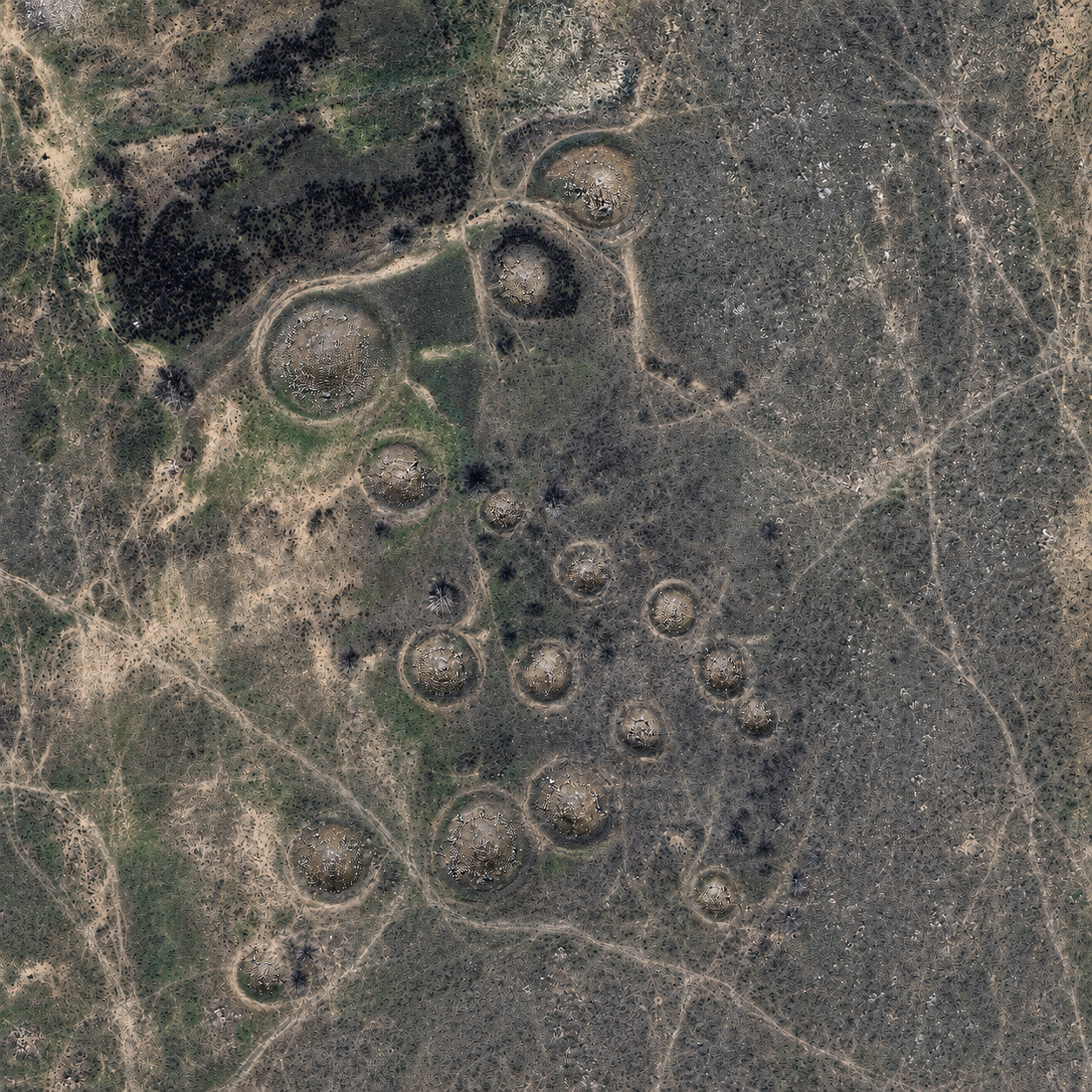
A hypothetical reconstruction of the Nardaran burial-mound field based on a satellite image
Until archaeologists obtain sufficient material, the most cautious conclusion is that the mounds were built by the ancient inhabitants of Absheron or by related communities of the eastern Caucasus.
Only archaeological examination of the burials can provide a more precise answer.
What may still remain inside
A looted burial mound is not necessarily empty, nor does it lose all scientific value.
Looters usually searched for objects that could be quickly removed, used or sold: metal weapons, jewellery, vessels and symbols of status. But archaeological information is not limited to valuable objects.
Fragments of pottery, human and animal bones, charcoal, remnants of wooden structures and small objects overlooked by looters may still survive inside damaged burials. Even the composition of the soil and the arrangement of stones can provide information about funerary practices.
Pottery can help establish cultural connections and the approximate age of a monument. Bones may reveal the sex, age, health and diet of the people buried there. Charcoal and other organic remains can be used for radiocarbon dating.
For an archaeologist, however, the location of an object matters as much as the object itself. When a burial chamber is disturbed, artefacts are displaced, soil layers become mixed and part of the information is lost forever.
The central cavities in the Nardaran mounds are therefore more than traces of past looting. They are open wounds through which the monument’s destruction continues.
Protection on paper
The condition of the burial-mound field presents a paradox.
This is not a newly discovered site whose legal status has yet to be determined. The state has already recognised it as a monument of national importance, identified its location and assigned it a preliminary date. Yet it is difficult to find signs on the ground that a special protection regime is in effect.
State registration should mean that the boundaries of the monument are precisely defined and that excavation, construction and other economic activity are carried out in accordance with cultural-heritage protection laws.
But a number in a register cannot protect an archaeological layer from an excavator.
Effective protection requires the coordinates of the surviving mounds and the boundaries of the entire necropolis and its buffer zone to be known. This information should be included in land-cadastre records and urban-planning documents. Information signs should be installed, and the condition of the monument should be inspected regularly.
Otherwise, the site exists for officials and specialists with access to the state register but remains invisible to landowners, construction companies and local residents.
It is unclear whether a complete re-inventory of monument No. 534 has been conducted in recent years. It is also unknown whether its buffer zone has been approved, whether an up-to-date monument passport exists or whether its boundaries are reflected in cadastral documents.
Nor is there publicly available information about when specialists last inspected the burial-mound field, whether looting and damage were documented, whether nearby construction was approved or which agency is directly responsible for the site’s present condition.
Answers to these questions could explain why a monument of national importance has been left practically defenceless.
The city draws closer
Nardaran ceased long ago to be an isolated coastal village. Residential and summer-house construction is expanding, open land is being divided into plots, and new walls, roads, utility lines and outbuildings are appearing.
Such an environment is particularly dangerous for an archaeological site. Most burial mounds do not resemble monumental structures. They are low hills that someone unaware of their origin might regard as unwanted irregularities to be removed.
A few hours of work by heavy machinery can destroy what survived for thousands of years.
If the boundaries of the burial-mound field are not marked, owners of adjoining plots may not know that the monument exists. If archaeological zones are not incorporated into cadastral plans, decisions about land use may be made without considering the historical layers beneath the surface.
But landowners’ lack of knowledge does not absolve the state authorities of responsibility. On the contrary, the site’s official status creates an obligation to make the protection regime clear, visible and enforceable.
A line in the state register must have a physical counterpart on the ground.
What can be done now
A complete new inventory of monument No. 534 could be the first step.
Modern technology makes it possible to begin the investigation without large-scale excavation. Drone photography could produce a detailed three-dimensional model of the terrain. Comparing archival and contemporary satellite images would show which mounds have disappeared or changed over recent decades.
Ground-penetrating radar and magnetometry could identify underground chambers, stone structures and burial boundaries without opening the mounds. Specialists could then record the coordinates of each surviving feature, determine the boundaries of the necropolis and identify its most vulnerable sections.
The already-looted mounds require particular attention. Their central sections should be investigated and stabilised before water and wind completely destroy any surviving structures.
This does not mean that the entire field must be excavated immediately. Modern archaeology often favours preserving part of a monument for future generations, whose researchers may be able to study it using more advanced methods.
But the disappearance must first be stopped.
An archaeological park instead of a wasteland
The Nardaran necropolis does not necessarily need to become a large museum complex. A more realistic solution might be a small open-air archaeological park.
After investigation and conservation, the surviving mounds could remain in their historic landscape. A walking trail could connect them with other monuments in Nardaran and northern Absheron. Information boards could explain the Bronze Age, the construction of burial mounds and the history of settlement on the peninsula.
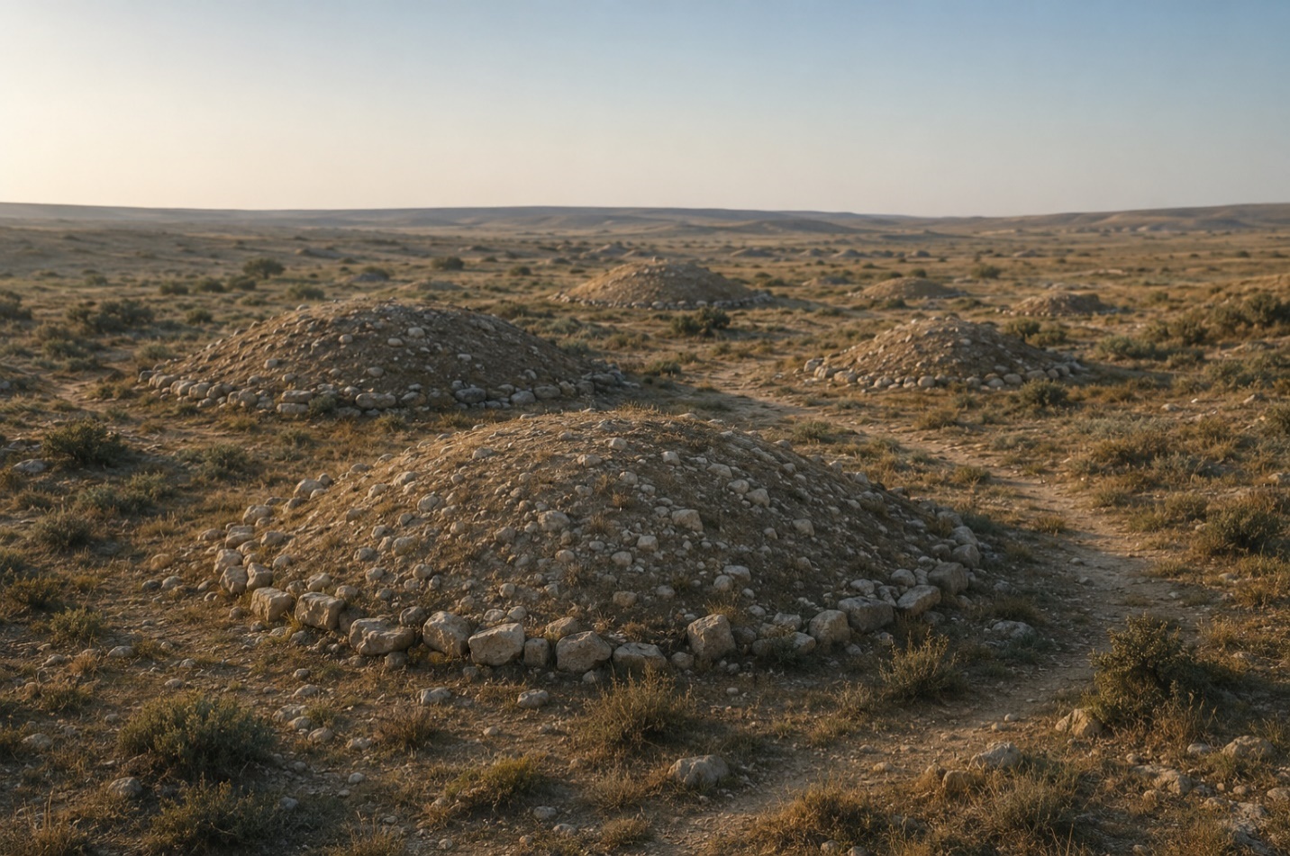
A hypothetical visual reconstruction of the burial mounds
A digital reconstruction could show visitors what the necropolis may have looked like before it was looted and before modern development expanded around it. Any representation of its original appearance, however, would have to be clearly identified as a scientific hypothesis. Satellite imagery can reveal the location of the mounds, but not their exact ancient height or construction.
Such a park could serve scientific, educational and protective purposes at the same time. Clearly marked boundaries, the regular presence of visitors and public attention often protect an archaeological monument more effectively than an inventory number.
Will anything remain besides the number?
The Nardaran burial-mound field does not need to be recognised again. The state has already recognised it as a Bronze Age monument of national importance.
It has a number — 534.
It has an officially recorded location — east of Nardaran.
It has a preliminary date — the Bronze Age.
But in time, the monument itself may no longer exist.
History does not disappear only when a famous palace is demolished or an ancient fortress is destroyed. Sometimes it vanishes almost unnoticed: one hill is levelled, another is enclosed behind a wall, and a third is washed away by rain. A wasteland remains where the necropolis once stood, while the state register retains a line that no longer corresponds to anything on the ground.
Answers to questions about the earliest inhabitants of Absheron may still lie beneath the Nardaran mounds. But there is less and less time to preserve them.
Unless a new inventory is conducted, protective boundaries are established and archaeological investigation begins, all that may remain of the burial-mound field is a record:
“No. 534. Burial-mound field. Bronze Age. East of the settlement of Nardaran.”
The monument will remain in the register. On the ground, perhaps it will not.
To be continued
Previous articles:
The Mystery of the “Hunnic Cemetery”: What Is Hidden in Buzovna’s Forgotten Necropolis?
The Stone That Survived the Centuries
Where History Has Not Yet Ended


Social
-
BAKU, July 31 — Azerbaijan faces a difficult choice between the two main power centres in world football after the Union of European Football Associations (UEFA) threatened to boycott all competitions organised by the International Federation of...
-
Traffic in central Buzovna continues to be shaped by the consequences of an accident that has formally been resolved. The groundwater leak has been stopped, but the damaged road has not been restored. For nearly a month, buses and cars have been forced to bypass the closed section by using other streets in the settlement.
-
Behind the high stone wall of an ordinary private home in Buzovna stand several ancient gravestones. They are not part of a decorative garden, nor were they moved there by archaeologists. The house simply happened to be built on the site of an old...
-
The participation of Armenian wrestlers in the U17 World Championships will test whether the cautious political dialogue between the two countries can move beyond negotiating rooms. If one of Armenia’s young wrestlers climbs to the top of the podium...


Leave a review